EcoTransit Proposed Future Sydney Rail Network (September 2025)
Sydney Metropolitan Public Transport – Spider Web Network by EcoTransit
Sydney’s Rail Network is basically a series of radial lines from the Sydney CBD to the north, south west and the one line east to Bondi Junction. This is fine if you live near one of the radial routes and travel towards/to the CBD.
Anyone who lives away from one of the current rail lines or has to travel across suburban areas for work, study or leisure is forced to either drive, adding to pollution and co2 emissions, or change modes one or more times to reach their destination thus dramatically increasing journey times.
Sydney’s future network needs a “spider web” of public transport especially heavy rail and light rail.
How to develop the “spider web”:
- Increase efficiency of rail services by more circular routes and, where possible, avoidance of terminating trains. The best example is the City Circle – prior to Circular Quay station it was necessary to terminate trains at St James and Wynyard. If the City Circle is having difficulty coping with the volume of passengers today just think how bad things would be without Circular Quay station completing the circle!
- Buses are not suitable for the main transport system in high density areas such as the Eastern Suburbs, Inner West, and Manly/Warringah areas – light rail should be provided. Buses would still be used but as feeders to light or heavy rail with appropriate interchanges at strategic locations.
- Metro rail is not suited for long distances unless it passes through major conurbations where people get off and others get on. It is unfortunately too late to stop the fake metro the government has built but we need to ensure that no more existing rail lines using Sydney’s famous double deck electric trains are converted and all additional lines be built to those standards.
- Sydney needs to have another look at Bradfield’s plans in light of the massive expansion of the Sydney metropolitan area and rail developments and options in more recent years. Public transport needs should not be decided according to how an area votes in either state or federal elections. What follows obviously could not be built overnight but without a comprehensive plan nothing will happen.
- The various heavy rail and light rail proposals will need to be prioritised and constructed accordingly. However, without all these proposals being built within the next 15 to 20 years Sydney will be severely disadvantaged economically and the population’s mobility will be increasingly curtailed with the necessity to dramatically reduce greenhouse gases.
- Naturally, many people will say these proposals are unaffordable. However, if prioritised and completed over a number of years this is not necessarily true. I would suggest that the government should establish and sell dedicated public transport treasury bonds to finance these projects.
Options to Improve Heavy Rail Routes
- Provide a triangle at Glenfield so that trains no longer have to terminate at Revesby, East Hills, or Liverpool. Instead, they would complete a circular route in both directions.
- Extend the Leppington Line through to Western Sydney Airport (Badgerys Creek) and onto St Marys including a triangular junction with the Main Western Line. An additional option would be to also extend this line to connect with the Richmond Line, probably at Schofields. The junction should be triangular so that trains could alternatively travel onto Richmond or the City; those travelling to the City would again eliminate the need to terminate. If the “metro” were extended from Tallawong to Schofields it would create an interchange. The Richmond line should be duplicated.
- A triangular junction at Leppington would provide a new line to Narrellan and Camden and re-join the Main Southern Line (again with a triangular junction) just south of Macarthur. This would allow freight trains from the Blue Mountains and the west to avoid the suburban lines east of St Marys to access a completed Maldon-Dombarton line and use Port Kembla as a port, also south to Bomaderry.
- The main western line from St Marys to Penrith would be quadruplicated to allow more frequent services.
- Extend the eastern suburbs line to North Bondi, Bondi Beach, Bondi and back to Bondi junction to complete a circle and avoid the need to terminate trains.
- Utilise the junction just north of Epping where trains to and from Hornsby used to enter the Epping to Chatswood line before the conversion to “metro” to access new underground platforms and continue Ryde – Gladesville – Abbotsford – Five Dock – Ashfield – Campsie – Kingsgrove – Bexley – Hurstville.
- At Hurstville there would be a link to the existing Illawarra line. This would allow not only some direct suburban trains from the Illawarra line to utilise the new link, but also make it possible for trains from the South Coast to travel via this link through to the Central Coast.
Reinstate Services Discontinued Since 2013
A very cheap option to reintroduce the following services that were discontinued by this government to the detriment of people travelling across suburbs is the following:
- Reintroduce the Bankstown circle trains instead of terminating them at Lidcombe and Homebush. Passengers travelling from the Bankstown line to Flemington, Homebush, Strathfield, Burwood etc. Now have to either change trains at Lidcombe or travel into the City, around the circle and out to those stations (at least as far as Homebush). It is inefficient to terminate trains when they can keep operating in a circular route.
- Reintroduce trains to Liverpool via Regents Park (former Inner West Line). People who currently need to travel to stations beyond Regents Park now have to change trains. If they are travelling from Western Line stations between Sydney and Lidcombe, they can travel on Leppington trains via Granville but that is a longer journey, but between Regents Park and Carramar they have to change trains.
- Save the Bankstown Line and the communities that stretch out along it, the Metro should be diverted from Sydenham on a route that currently does not have a rail service. This would actually expand Sydney’s rail network and not just replace one service with another inferior service.
- EcoTransit has identified an alternative route that would not only provide a rail service to an area that currently has none but would also be an alternative to the F6 toll road to the Sutherland Shire. The route would take the Metro South through Sans Souci, across the Georges River to a terminus at Miranda, where there would be an interchange with the Cronulla Line.
- This alternative to the F6 toll road would be cheaper to construct than the motorway and would have the added benefits that it would have a higher capacity per hour and provide a faster rail service to Sydney CBD than is currently possible via Sutherland and Como.
- The NSW government’s proposed “Metro” from the City to Parramatta should be constructed as full double deck size railway and would extend to Westmead. This would enable services from the blue mountains and express trains from Emu Plains/Penrith to reduce journey times by around fifteen minutes.
Options for Light Rail Routes
- A light rail line commencing at Cronulla station (approaching and departing by a loop so that trams would not need to terminate) and travelling to Miranda via Cronulla St, Surf Rd, Gerale St, Eloura Rd, Captain Cook Dr, Taren Point Rd, Kingsway and Kiora Rd. After passing under the railway at Miranda the line would loop around Gibbs St, Jackson Ave and Karimbla Rd to again avoid terminating.
- A junction at Miranda would see light rail travelling via Kiora Rd, Port Hacking Rd, Princes Highway, King Georges Rd, interchange with heavy rail at Hurstville (Illawarra Line), interchange with heavy rail at Beverly Hills (Airport and South Line), via Roselands shopping centre, interchange with heavy rail at Wiley Park (Bankstown Line), Punchbowl road, interchange at Burwood (Inner West Line), Concord, Cabarita, Mortlake, a circular route around Concord Hospital, interchange for heavy rail at Concord West (Northern Line) and re-joining route at Concord to complete circle.
- At Sutherland (see below) there would be a triangular junction with one line following the Princes Highway to Sylvania and junctioning with the line along Port Hacking Rd from Miranda (above).
- Another route from the Miranda interchange would continue along the Kingsway to Sutherland, across the Woronora river to Bangor, Menai, Alfords Point Rd, across the Georges river to Padstow Heights, interchange for heavy rails at Padstow (Airport and South Line) and Bankstown (Bankstown Line), Bankstown Central shopping centre, interchange for heavy rail at Lidcombe (Western Line), Silverwater, Ermington, interchange for heavy rail at Eastwood (Northern Line), Macquarie University, North Ryde, interchange at Macquarie Park (Sydney Metro Northwest), then via Ryde road, Mona Vale Rd, serving St Ives, Terry Hills, Mona Vale, then via Pittwater Rd to Warriewood, Narrabeen, Collaroy, Dee Why, Warringah Mall shopping centre (junction with a line from Chatswood), junction with one line continuing along Pittwater Rd to interchange at Manly (Manly Wharf), then via Sydney Rd to Balgowlah, Seaforth (junction with main line which travelled via Condamine St and Burnt Bridge deviation), new high level light rail and road bridge at The Spit, Balmoral, Spit Junction, Cremorne, Neutral Bay, interchange for heavy rail at North Sydney (North Shore Line), Crows Nest, St Leonards (North Shore Line), Gore Hill, Lane Cove, and back to Macquarie Park with a triangular junction.
- The line from Warringah Mall to Chatswood would serve Beacon Hill then via Warringah Rd to Frenchs Forest, Forestville, Roseville Chase, Willoughby North, interchange for heavy rail at Chatswood (North Shore Line), Lane Cove then via the M2 motorway route to Macquarie Park and the previously mentioned triangular junction.
- The Sydney CBD and South East Light Rail (CSELR) would be extended from the existing terminus and once again use the old tram right of way through Maroubra Junction to La Perouse using the same circle the trams used to turn back towards the city. At Maroubra Junction there would be a line to Maroubra via Fitzgerald Rd (junction with line linking to Sydney Airport etc below) and then back through Coogee, Prince of Wales Hospital, Randwick, then via Allison Rd including Randwick Racecourse back to a junction near Moore Park.
- At the intersection of Anzac Parade and Bunnerong Rd a junction would follow Bunnerong Rd through Matraville, Hillsdale (junction with line from Maroubra Beach via Fitzgerald avenue above), via Wentworth Ave to Eastgardens (Westfields shopping centre), across Botany Road at Mascot onto Joyce Dr with a loop around the Domestic Airport terminal, then Qantas Dr & Airport Dr to the International Airport terminal, across Cooks River, via the Marsh St bridge, then via the motorway route – underground – and a to be determined route to join the Goods Railway route around Marrickville. From Dulwich Hill the line would follow the Goods Railway route to link up with the existing light rail line at Lilyfield.
- The existing T-Way from Parramatta to Rouse Hill would be converted to light rail with a interchange for heavy rail, along the old Windsor Rd route, and then continue from Rouse Hill to a interchange for heavy rail at Riverstone (Richmond Line), Marsden Park, Bidwell, interchange for heavy rail at Mount Druitt (Western Line), Minchinbury, then via the Great Western Highway/M7 motorway route to a interchange for heavy rail at Rooty Hill (Western Line), Plumpton, Oakhurst, Glendenning then a triangular junction with the route coming across from Rouse Hill.
- The existing T-Way from Blacktown to Parklea adjacent to Sunnyholt Rd would be converted to light rail and would continue to Kellyville, Castle Hill, Rogans Hill, West Pennant Hills, Carlingford North, Carlingford Station (light rail interchange), then following Pennant Hills Rd to North Parramatta and Parramatta – linking with the light rail route to Rouse Hill and with interchange for heavy rail. The Westmead – Parramatta – Carlingford line (Parramatta Light Rail Stage 1) currently being built must be extended to Epping to interchange with both the heavy rail and “metro”.
- The existing T-Way from Parramatta to Liverpool would be converted to light rail. It would continue from Liverpool via Newbridge road to Milperra where it would junction. One route would continue to Bankstown with a triangular junction with the light rail route previously mentioned. The other route would follow Henry Lawson Dr to Georges Hall, Lansdowne, then via Woodville road to an interchange for heavy rail at Villawood (Bankstown Line), and onto Harris Park and Parramatta.
- From Circular Quay there would be a triangular junction at George Street with a line turning right and following the lower end of George St, then Hickson Rd, serving Barrangaroo, Sussex street, at Park St there would be a junction with one line turning left into William St to Kings Cross, through the tunnel to Rushcutters Bay, then following New South Head Rd to Double Bay, Rose Bay, to Watsons Bay where there would be a loop. The other line would continue along Sussex St to Hay St and junction with the existing light rail line.
- Light rail should be extended along George St, Broadway, and Parramatta Rd to Strathfield and on to Olympic Park. A branch at Norton St, Leichardt would provide good service to that area. If the original Parramatta Light Rail proposal were constructed that would also link with the above line at Olympic Park.
- To avoid the congestion that would result in George Street with both the City and South East Light Rail (CSELR) and Parramatta Road trams using that route it would be a good idea to re-route the CSELR trams via Elizabeth St, Chifley Square, Bent St, Young St, and return to Elizabeth St via Phillip St.
- The above proposals for light rail are not exclusive and the suggestion for a light rail loop serving Green Square is a good one. This loop could be extended and linked into several of the proposals detailed above.
September 2025 Updates
- Extension of Sydney Metro Northwest to Schofields.
- Extension of Sydney Metro – Western Sydney Airport line to Schofields.
- Please see EcoTransit’s Dharawal Line proposal for details regarding the New T5 Cumberland Line and the Bradfield to Campbelltown line.
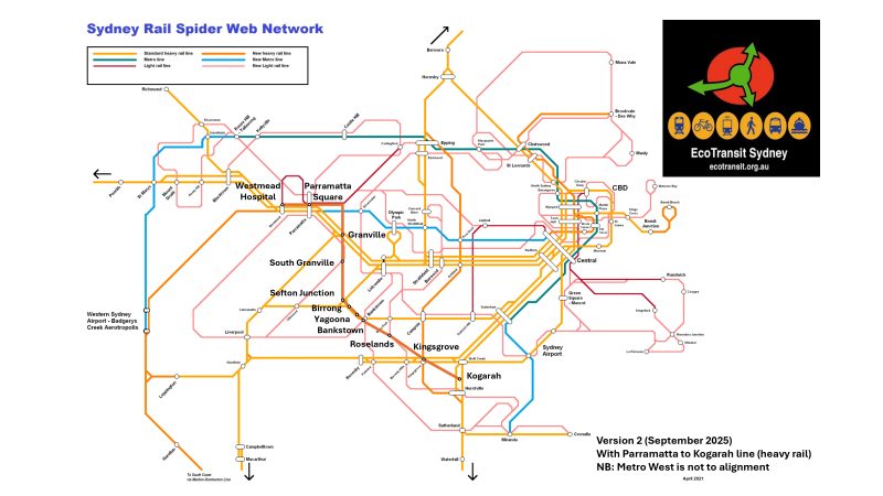
- Westmead to Kogarah line (heavy rail): Westmead Hospital (new), Parramatta Square (interchange with Metro West), Granville (interchange with T1), South Granville, Sefton Junction (new and interchange with T3), Birrong, Yagoona, Bankstown, Roselands, Kingsgrove (interchange with T8), Kogarah (interchange with T4).