Seventeen years have passed since the Carr Government’s 1998 “Action for Transport 2010” blueprint, which promised a slew of new public transport and motorway infrastructure.
While only a fraction of the promised rail and bus projects were delivered, the Roads and Traffic Authority built all of its roads, plus others that weren’t in the plan. And yet road congestion costs have continued to escalate.
Sydney needs a better approach, but the RTA is pushing to duplicate the M5 motorway with a $4.5 billion price tag that would prohibit any other significant infrastructure being simultaneously constructed.
If their plan goes ahead the North-West and Parramatta–Epping rail links would have to be put off for a decade.
In response, EcoTransit Sydney and the Australian Conservation Foundation have developed an alternate 9 point transport plan that offers a cheaper and sustainable alternative to continued motorway expansion.
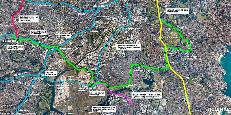
An important component of the plan is the East-West TransLink. The TransLink is a high-capacity double-track light rail service running from Dulwich Hill – using the spare space in the heavy rail corridor along the Bankstown line – to Sydenham station and then proceeding beside the Botany Goods line with stops at Qantas Jet Base and the Domestic Terminal before cutting through Eastlakes and along Gardeners Road to Anzac Parade, UNSW, Randwick Hospital and ideally, for good measure, Coogee Beach. The line would complement one running down Anzac Parade from the CBD, in the historic tram corridor.
By providing a new cross-radial link between the existing inner west and south-west heavy rail lines, it will improve public transport access from South-West Sydney to major trip generators in South-East and Central Sydney. South-East and Central Sydney contain important transport, educational and health centres that are difficult to reach via public transport. These employment and transport hubs include:
- Sydney Airport
- Port Botany
- The University of NSW
- Prince Of Wales and Children’s Hospitals
- Mascot and Botany industrial precincts