
Why Camden to Macarthur needs light rail — and the 14,000 cars it takes off Narellan Road
Between Camden and Macarthur Station there are 78,000 people, and one road.
Narellan Road was widened from two lanes to three each way in 2018. It cost $152 million, rebuilt ten signalised intersections, and widened the bridge over the Hume Motorway — a structure carrying about 100,000 vehicles a day. It bought roughly a decade. The road is congested again.
There is no fourth lane. The corridor is boxed in by the Hume interchange at one end and the Camden Bypass junction at the other, with property, drainage and utilities constraining everything in between. Camden has added more than 15,000 residents since the widening, with another 105,000 forecast in the corridor catchment by 2041.
The road solution has been used. The question now is what replaces it.
Why the corridor needs light rail
Because there is currently no alternative at all. The entire bus network serving these 78,000 people carries about 3,900 trips on a weekday — five trips per hundred residents per day. Camden, Narellan Vale, Mount Annan, Spring Farm and Elderslie are struggling with population growth not supported by public transport. Every new household in the Greater Macarthur build-out arrives with two cars because nothing else is on offer, and every one of those cars uses Narellan Road.
Because the demand is already there. Nearly half of every Opal tap across the 611-stop Campbelltown–Camden bus network happens within walking distance of the proposed stops. Routes running along the alignment carry 58% of all trips — with no trunk service, no priority and nothing encouraging that pattern. The corridor already behaves like a rail line. It just has no rails.
Because the Government’s own forecasts show the bus running out. TfNSW modelling for Route 845, which shares the Narellan Road trunk, projects AM peak demand growing from 108 to 426 passengers an hour by 2036 — 3.9 times, assuming no rail extension and no extra land use change. A 30-minute bus carries about 150 an hour. The corridor outgrows conventional bus operation within a decade.
Because buses can’t fix a road problem while sitting in the road. More buses on Narellan Road means more vehicles in the same congested general traffic lanes. Only a new light rail line moves more people without adding vehicles.
Park-and-ride pressure at Macarthur and Cambelltown falls. A large share of corridor residents currently drive to Macarthur or Cambelltown Station to catch the T8 Line. A light rail stop at Macarthur Station, 17 minutes from Narellan, converts those car trips into walk-up light rail trips — and frees station parking and congestion in the town centres.
Eleven bus routes stop competing for the same road space. The restructure withdraws trunk bus kilometres from Narellan Road and Camden Valley Way entirely. That removes buses from the general traffic lanes as well as cars.
How many cars come off the road
The line is forecast to carry 34,000 boardings a weekday at maturity. On deliberately conservative assumptions — 60% of those trips diverted from car, 1.2 people per vehicle — that is:
| Camden to Macarthur Light Rail | Boardings/weekday | Car trips removed |
|---|---|---|
| Opening, 2035 | 15,500 | ~7,750 |
| North South Rail link at Narellan, 2043 | 25,000 | ~12,500 |
| Maturity, 2051+ | 34,000 | ~14,000 |
Roughly 14,000 vehicle trips off the corridor every weekday, concentrated on Narellan Road and Camden Valley Way, and weighted to the peaks — where they hurt most.
That 60% diversion rate is conservative for a corridor where most residents have no competitive alternative today. Where a new line opens into a place with decent existing transit, diversion is far lower. Here, almost every new light rail trip is a trip that would otherwise have been driven.
The capacity argument, in one line
Reallocating a traffic lane on Narellan Road looks like a cut to capacity. It is the exact opposite.
| One lane, one direction | People per hour |
|---|---|
| General traffic | ~920 |
| Light rail, 10-min headway | 1,800 |
| Light rail, 7.5-min headway | 2,400 |
| Light rail, 6-min headway | 3,000 |
The lane taken for light rail moves two and a half to three times as many people as it did carrying cars — and it does so reliably, because a segregated reservation with absolute signal priority doesn’t degrade in the peak the way a traffic lane does.
A built-out arterial can only gain capacity by giving up road space. That is the whole argument.
What it takes
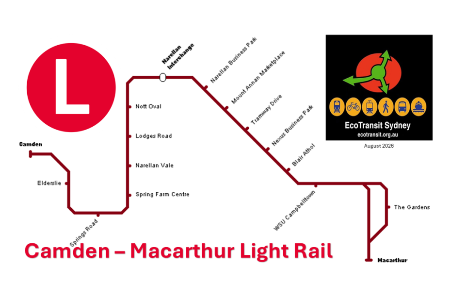
22 kilometres, Macarthur Gardens to Camden, around fifteen stops, 41 minutes end to end at 32 km/h — a genuinely fast line with stops averaging 1.47 km apart. $2.05 billion, or $93 million per kilometre with a benefit-cost ratio 1.13. If planning commences in 2027-28, the line opens in 2035, with the bus network restructured as feeders from day one.
And it needs to be decided now. The North South Rail Link corridor to Narellan is already confirmed, with $1 billion committed federally to protect it. But that line won’t stop in Camden, Narellan Vale, Mount Annan, Spring Farm and Elderslie. Build the light rail first and the North South Rail Link opens into an organised catchment. Build it second and it opens into a car park.
Overview
Termini: Macarthur, Camden
Interchange: Macarthur (T8, Southern Highlands Line, Bus); Narallen (North South Rail Link, Bus), Camden (Bus)
Stops: 14-16
Depot: adjacent to Narallen Business Park (or adjacent to Camden Fire Station)
Rolling stock: Melbourne E Class (Bombardier)
Track length: approx. 22km
Track gauge: 1,435 mm (4 ft 8 ½ in) standard gauge
Electrification: 750 V DC from overhead catenary
Potential Future Extension: Camden Hospital and Camden South (before Old Hume Highway)
Service Frequency
Weekday off-peak and peak: 8 trams per hour (every 7-8 minutes)
Weekday evening: 6 trams per hour (every 10 minutes)
Weekday late-night: 4 trams per hour (every 15 minute)
Weekends and public holidays: 6 trams per hour (regular); 4 trams per hour (early morning and late night)
| Campbelltown Light Rail Stops (Macarthur to Camden) | ||
| Proposed Light Rail Stop | Light Rail Stop Address | Island (middle median) or 2 Side Platforms |
| The Gardens | Gilchrist Dr before Englorie Park Dr, Campbelltown | 1 side platform only |
| Macarthur | Menangle Station, Menangle Rd, Campbelltown | Island (1 side platform only) |
| Macarthur Station (optional inbound) | Gilchrist Drive Overbridge | Inbound Side Platform with lift access to extended Macarthur Station platforms under bridge |
| WSU Campbelltown | Gilchrist Dr before Goldsmith Ave, Campbelltown | Island (middle median) |
| Blair Athol | Campbelltown TAFE, 181 Narellan Rd, Campbelltown | Island (middle median) |
| Nexus Business Park | Maryfields Lakeside, Narellan Rd, Campbelltown | Island (middle median) |
| Tramway Drive | Narellan Rd before Tramway Dr and Mount Annan Dr, Currans Hill | Island (middle median) |
| Mount Annan Marketplace | Narellan Rd after Hartley Rd, and Waterworth Dr, Mount Annan | Island (middle median) |
| Narellan Business Park | Narellan Rd before Exchange Pde, Smeaton Grange | Island (middle median) |
| Narellan | Narellan Town Centre, 326 Camden Valley Wy, Narellan | Island (middle median) |
| Nott Oval | Nott Oval, Richardson Rd after Elyard St, Narellan | Island (middle median) |
| Lodges Road | Richardson Rd after Lodges Rd, Narellan | Island (middle median) |
| Narellan Vale | Narellan Anglican Church, Richardson Rd after Bluebell Cres, Narellan Vale | Island (middle median) |
| Spring Farm Centre | Richardson Rd after Corder Dr, Spring Farm | Island (middle median) |
| Springs Road | Springs Rd before Ettlesdale Rd, Spring Farm | Island (middle median) |
| Elderslie | Burford Reserve, MacArthur Rd before Galvin St and Burrawong Cres, Elderslie | Island (middle median) |
| Camden | 100 Argyle St, Camden | Island (middle median) |